
Thursday, 31 December 2009


Wednesday, 30 December 2009


Monday, 28 December 2009


Saturday, 26 December 2009

The ITCZ drifting off to the NE

After a stop over with the Bradley's and Iain Baker, we are off on our last leg to Welkom. The howling wind has stopped.
Further down the track...

A perfect sky in the distant east, blue straight ahead. And the trough line from east to west


Tuesday, 22 December 2009


Monday, 21 December 2009
A full report on the Worcester Week
I did not get around to writing anything, and only posted a few photos, but the full story of the Worcester Week (12 - 19 December is to be found at Adri Hepburn's blog (http://www.adrihepburn.blogspot.com/) (or click on the title above) We flew for all but two of the seven days, and though the weather never really came up to scratch, it was great flying and, I believe, enjoyed by all).
EY
EY
Sunday, 20 December 2009


on glide to the last turnpoint

The setting sun, SE bound with the Southerly clearly visible on Brandvlei dam.
Convergence

On glide from Waaihoek I finished overhead the airfield, only to climb away in the convergence!
Here I am back at Brandwacht, heading towards with Audenberg, right up against the convergence cloud.
Thursday, 17 December 2009


Wednesday, 16 December 2009

Monday, 14 December 2009

Sunday, 13 December 2009


Friday, 11 December 2009
The first 3 days
An update for the Worcester Week
Briefing - clubhouse 9am sharp
Grid before 10am
First launch 10h15
Saturday
Surface wind - SWS 20, 5000ft SW 10, 10000ft WNW 20, 15000ft NW 30, 20000ft W 80
Shear is light at 10ms/4km and NO cat
Wave from 14500ft upwards at 2ms
Cloud BLEU
Max 31.6 Dewpoint 11.4 Trigger 29.5
Expect 1.5 ms - 1.9 ms to 7 000 ft
T-2 to 4300ft
boundary layer energy 85J/kg
Sunday
Anabatic cold front 142 km to the NNW moving 11kts to the NNW vertical motion 193m/hr (rain in 14 hours ie early MOnday morning,behind the surface front)
Surface wind - SE 40, 5000ft ESE 50, 10000ft SW 10, 15000ft WSW 30, 20000ft WSW 60
SEVERE SURFACE CAT and moderate from 6500 - 8500ft
Shear is moderate at 15ms/4km
Wave from 14500ft upwards
Cloud 3/8 from 3000ft - 5000ft
Max 20.9 Dewpoint 11.7 Trigger 20.4
Expect 0.7 ms - 1.1 ms to 5 000ft
We don't get to T-2
Boundary layer energy 36J/kg
Monday
Surface wind - ESE 20, 5000ft ENE 20, 10000ft NW 20, 15000ft WNW 30, 20000ft W 60
LIGHT CAT surface, 5 000 - 10 000ft
Shear is moderate at 12ms/4km
Wave from 12 000ft 1.8ms
Cloud BLEU
Max 28.8 Dewpoint 6.5 Trigger 26.3
Expect 1.2 ms - 1.6 ms to 6 200ft
T-2 to 5000ft
Boundary layer energy 88 j/kg
EY
Thursday, 10 December 2009
Le weekend - which becomes a week
The start of a whole week's flying at FAWC
I hope to do regular updates of the weather - but only to detail the next day or two
Briefing at 9h00 sharp and gridding before 10h00
Saturday we may have an early start to the day - SW's always bring early starts!!!
Saturday
Surface wind - SSW 20, 5000ft SW 10, 10000ft W 20, 15000ft NW 30, 20000ft W 70
Shear is low at 9ms/4km and CAT only above 14000ft
Wave from 14500ft upwards at 1.5 - 2.8ms
Cloud Bleu
Max 32.2C Dewpoint 10.7 C Trigger 30.1C
Expect 1.5 ms - 2.0 ms to 7000ftT-2 at 5000ft ;-)Boundary layer energy 87J/kg
Sunday
A strong inversion at 5000ft
Surface wind - SE 30, 5000ft E 50, 10000ft W 10, 15000ft W 40, 20000ft WSW 60
EXTREME surface CAT and Medium CAT at 6500 - 8000ft
Shear is moderate at 17ms/4km
Quasi-stationary anabatic warm front 250km to the NNW 96m/hr with rain in the next 24hrs
Wave from 12400ft upwards
Cloud BLEU
Max 22.2C Dewpoint 11.8C Trigger 21.6C
Expect 0.75ms - 1.1 ms to 4800ftBoundary layer energy 39 J/kg
Monday
32C, South East
Tuesday
Tuesday - Thursday - North West going West
Friday - South East
Saturday - Westerly
See you all at the 9h00 briefing on Saturday
EY
Tuesday, 8 December 2009


Friday, 4 December 2009
le (non legalese) weekend
Saturday - no flying due to FIFA 2010
Surface wind - SW 10, 5000ft WNW 10, 10000ft NW 40, 15000ft NW 70, 20000ft WNW 90
Windshear is high at 18ms/4km, but only light CAT from 8000ft upwards
Light wave from 6000ft upwards (and as always, should be contactable lower down in the Breede River valley)
Cloud Bleu
Max 31.2 Dewpoint 8.5 Trigger 28.7
T-2 at 6700ft!!!
Expect 2.3ms - 2.8ms to 9500 ft
Boundary layer energy a respectable 146 j/kg
Sunday - some flying for those with personal clearances.
Surface wind - Sw10, 5000ft NW 10, 10000ft NNW 30, 15000ft NW 80, 20000ft NW 90
Light CAT from 5000ft up, shear is higher at 20ms/4km
Wave from 8500ft upwards at 2m/s (but we should be able to get into, especially later in the day as the front moves in, or the cut-off low deepens)
Cloud 3/8 at 16 - 18ft; 5/8 from 28000ft upwards
Max 30.3 Dewpoint 11.5 Trigger 29.5
(we don't get to T-2)
Expect 1.0 ms - 1.3 ms to 5000 ft
Boundary layer energy (low) 30 J/kg
EY
PS the subsequent sounding for Sunday looked markedly better, and Volker and I will be in a Janus courtesy of Rudi - thanks Rudi)
Sunday, 29 November 2009
Not quite ...
... the weekend weather has not quite turned out as predicted, but here are some pics 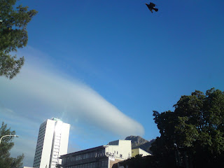


on the way home from work, a lenticular above Devil's Peak

Saturday evening lennies over Matroosberg

and a (spectacular) sunset from Du Toits Kloof pass


and a (spectacular) sunset from Du Toits Kloof pass

Friday, 27 November 2009
le weekend FIFA 2010
Saturday is going to be hot, but a lot like last Friday - with thermals far apart, but strong and to great heights
Sunday as a real super classic ridge day, but as yet I (and I assume many others) do not have their personal security clearances for flying - thanks to FIFA 2010)
Saturday
Surface wind - W 10, 5000ft WNW 20, 10000ft NW 30, 15000ft NW 50, 20000ft NW 60
Windshear is 10ms/4km With some strong gusts (exceeding 30kts!!!)
But only light surface CAT is indicated
Wave from 10 000ft upwards
Cloud BLEU
Max 34.2 Dewpoint 3.3 Trigger 32.2
Expect 2.0 ms - 2.5 ms to 8600ft
T-2 at 5000ft
Boundary layer energy 104 J/kg
IF we get to the predicted 37C
THEN Expect 2.7ms - 3.2ms to 10 500ft
339J/kg
Sunday
(if cleared by FIFA) THE DAY OF DAYS
Surface wind - SW 20, 5000ft SW 20, 10000ft W 40, 15000ft W 80, 20000ft W 100
Wave from 10 000ft upwards
Cloud BLEU
Max 25.2 Dewpoint 9.9 Trigger 22.4Expect 1.5 ms - 1.9 ms to 7 000 ft
T - 2 to 6000ft!!!!123 J/kg
Monday, 23 November 2009
Sunday, 22 November 2009
The Wasserkuppe comes to Worcester
The prediction for Friday was not too far out - it turned out to be a light NE, giving good climbs (sometimes 4m/s to 10 000ft) but the thermals were far apart (but when you are high it is not too bad ;-) 
Going north, Citrusdal ahead ...


I flew in the back seat with the CFI of the Wasserkuppe, Harald Joerges in Hubert's DG500 (thanks to Rudi and Hubert). The flight is on OLC (logger problem, which does not show the low save close to the airfield, courtesy of Harald - who did all the flying, or that we did well in excess of 400km).
Here are some pics taken high over the unlandable terrain of the Groot Winterhoek mountains.

Going north, Citrusdal ahead ...

Looking back South, not often that we see it from this perspective ...


Climbing at 4m/s plus, looking down at the Dasklip PG launchsite

The sun sets (a picture from the Saturday)

Taken from Du Toitskloof pass on the way home ...
the lower cloud will bring some fresh air for Sunday's flying (when Mike Young will be flying in the Taurus with Martin Gruenert, thanks Martin).
EY
Thursday, 19 November 2009
Le weekend 21 November 2009
This is a forecast which includes tomorrow, Friday the 20th.
Temps are up and we are, at long last, seeing T-2 on the soundings, which holds good promise for soaring conditions.
Friday
Surface wind - WNW 10, 5000ft NW 20, 10000ft NWN 30, 15000ft NWN 30, 20000ft WNW 20
Windshear is unusual at 5ms/4km, but a high surface Cat is predicted.
Wave only from 16 000ft upwards
Cloud BLeu
Max 31.6 Dewpoint 6 Trigger 29.6
Expect 2.2 ms - 2. 7 ms to 9 000 ft
T-2 to 5000ft
Boundary layer energy 121 J/kg
Saturday
Surface wind - W 20, 5000ft WNW 20, 10000ft, NW 60, 15000ft WNW 50, 20000ft WNW 30
Windshear is 9ms/4km and the high surface CAT remains as on Friday
Wave light, but from 6000ft upwards
Cloud Bleu
Max 28.2 Dewpoint 9.8 Trigger 26.4
Expect 1.2 ms - 1.7 ms to 6800 ft
T-2 to 4000ft
Boundary layer energy 77 j/kg
Sunday
Surface wind - S 10, 5000ft E 10, 10000ft NW 30, 15000ft NW 40, 20000ft NW 20
High surface cat remains as in the previous days, with moderate cat from 4500ft upwards
windshear remains moderate for FAWC at 11 ms/4km
Wave from 10 000ft upwards
Cloud blue
Max 26.9 Dewpoint 9.9 Trigger 24.9
Expect 1.0 ms - 1.4 ms to 5200 ft
T-2 to 4000ft
Boundary layer energy 78 J/kg
regards
EY
Wednesday, 18 November 2009
Thursday, 12 November 2009
Le weekend - 14 November
The NWester is still blowing (unabated now for 7 days - not often that we see that in November, but when it does happen Bitterwasser and Pokweni suffers, and OLC reveals that) but the sun is peeking out behind Lionshead, and by noon tomorrow the rain should disperse and by Sunday the Cape Doctor will be howling.
The weekend looks like this
Saturday
Surface wind - WSW 20, 5000ft WSW 20, 10000ft W 50, 15000ft W 110, 20000ft WSW 150!!!Strong surface turbulance
Shear is moderate at 18ms/4km
Wave from 10000ft, 12000ft,16000ft at 3m/s (as always expect it much lower in the valley and with the Westerly it should be contactable (and i really want to test my Trig21 mode S transponder ;-)
Cloud 3/8 at 5000ft
Max 17.9C Dewpoint 6.4C Trigger 15.5C
T-2 to 5000ft (we haven't seen that for quite a while)
Expect 1.3 ms - 1.8 ms to 6 800 ft
108 Joule/kg
Sunday
The SE sets in, with a strong inversion at 7500ft and westerlies above that. Sounding shows a katabatic cold front 80km to the NE, Vertical motion -1325m/hr
Surface wind - SE20, 5000ft SE 20, 10000ft W 30, 15000ft WSW 80, 20000ft WSW 110
VERY Strong surface turbulence - WATCH the ridges, also the strong shear conditions at 6800 - 8000ft
Shear is 20ms/4km
Wave - from 10200ft upwards to 27000ft at 2 - 3m/s (but probably out of reach of all but a DG808)
Cloud Bleu
Max 17.7 Dewpoint 6.1 Trigger 16.1 Expect 1.0 ms - 1.4 ms to 5500ft
63 J/kg
EY
Saturday, 7 November 2009


Subscribe to:
Posts (Atom)

